
Photographic Tour of Cane Hill Battlefield - Canehill, Arkansas
ExploreSouthernHistory.com - Battle of Cane Hill, Arkansas
ExploreSouthernHistory.com - Battle of Cane Hill, Arkansas
| | | | |
The Battle of Cane Hill, Arkansas
The site of the Battle of Cane Hill has not been preserved, but many areas of the battlefield can be seen from public roads.
Interpretation is limited to a single historic marker on Highway 45 in Cane Hill. If you decide to visit the battlefield, please
respect the rights of property owners. To view larger versions of any of the photographs below, please just click on the
image.
Interpretation is limited to a single historic marker on Highway 45 in Cane Hill. If you decide to visit the battlefield, please
respect the rights of property owners. To view larger versions of any of the photographs below, please just click on the
image.
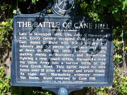
| The Battle of Cane Hill marker on Highway 45 in Cane Hill. There is very little interpretation available on the battlefield. |
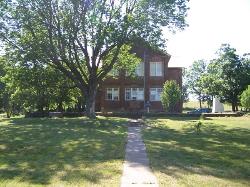
| The old Cane Hill College building still stands in Cane Hill. This structure is of post-Civil War construction, but the site was a functioning college when the war erupted. |
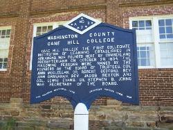
| The historic marker at Cane Hill College. This institution was the first college in the state of Arkansas and was a predecessor of today's University of the Ozarks. |
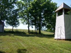
| This is a view looking west from the college grounds to the commanding hill overlooking the town. Confederates used hills like this as artillery positions during the battle. |
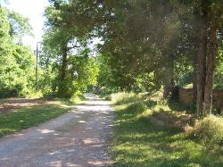


| The old road leading by the college is one of the original roads of the town. The Federal troops attacked from the north. |
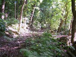
| The Confederates took advantage of ravines like this one to force the Federals to attack on narrow fronts. |
| After the fighting moved beyond Cane Hill (actually three connected villages), it spread into ridges south and southeast of town. |
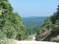
| The Confederates made a determined stand on the mountain separating Cane Hill from the Cove Creek valley. Heavy fighting and shelling took place here where the old road crosses over the mountain. |
| After the fight on the mountain, the Federals pursued the Confederates down into Cove Creek Valley. This valley was a scene of constant activity during the war as both armies marched back and forth along Cove Creek Road. |
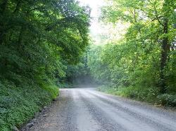
| The final shots of the battle took place near here on Cove Creek Road. The road passes through a narrow spot where the Confederates were able to lay a successful ambush and drive back the Federals. Darkness and a Confederate request to remove dead and wounded brought an end to the battle. |

Custom Search
| Copyright 2011 by Dale Cox All rights reserved. |